There are a range of city-wide strategies and policies in place to address challenges around flooding, the housing crisis, and Bristol’s future transport and connectivity needs.
The text below explains key city issues that the Western Harbour project will need to respond to as part of a joined up approach to place-shaping. For further information, please refer to the links below.
Bristol Avon Flood Strategy (BAFS)
What is the flood strategy?
The Bristol Avon Flood Strategy will create new flood defences or raise the level of existing flood defences in phases along lengths of the River Avon from Swineford, through Bristol and downstream to Sea Mills and Shirehampton. The majority of the scheme is located along the north bank of the River Avon from where it meets Cumberland Basin, up to Netham Weir and beyond to St. Anne’s Park.
The preferred approach is to build in phases. Bristol City Council will monitor and adapt the approach to respond to the threat of flooding. Defences will be constructed in a way to allow them to be raised in the future to respond to rising sea levels and climate change.
BCC’s vision is to create flood defences that integrate with their surroundings and create high quality public spaces or support walking and cycling, so that these areas can be used and enjoyed during the vast majority of the time when there is no flooding.
Why is a strategy needed?
Without a strategy to reduce the risk of flooding across the city, existing homes and businesses remain at risk of widespread flooding from the River Avon. A severe tidal flood today would result in around 1,000 existing homes and businesses being flooded near the city centre and 400 in neighbouring communities. This would have an impact across the West of England because of Bristol’s importance for jobs, transport, recreation, tourism, and the economy.
Climate change is increasing sea levels and high river-flows, all of which increase the risk of flooding. Without action, by the end of the century almost 3,100 existing properties could be at risk in severe floods.
We need a long-term strategic approach to flood risk management to future proof our city and neighbouring communities. Measures need to be joined up, so that better protecting some locations at flood risk does not increase the flood risk elsewhere.
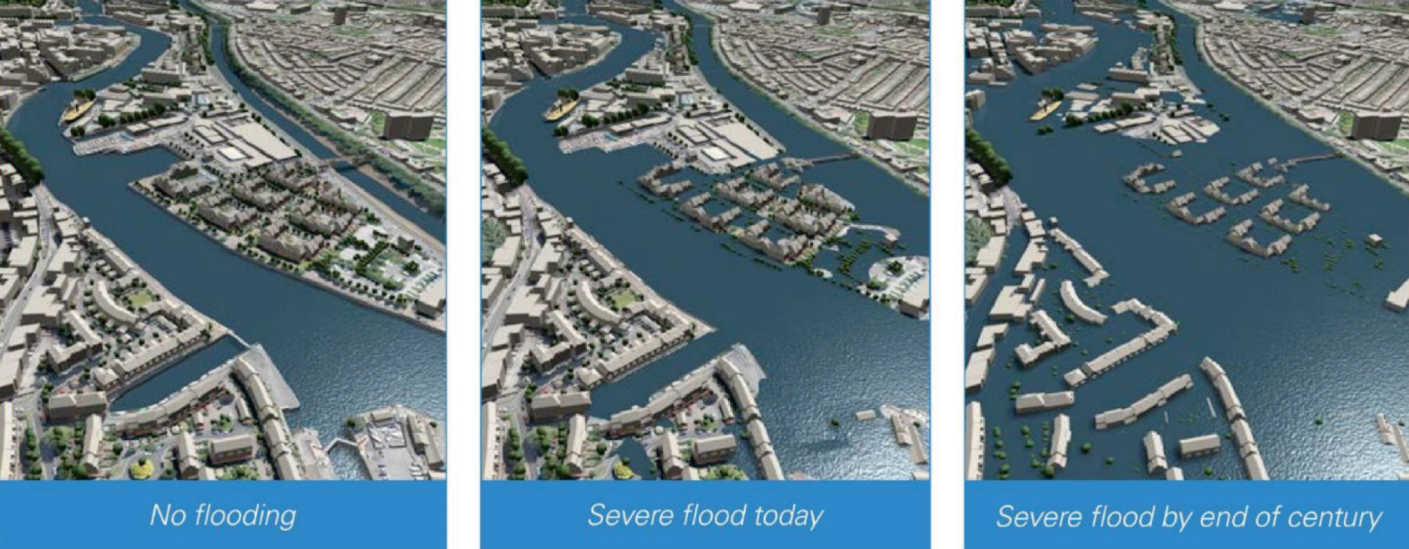
A visualisation of flood risk predictions looking east – Hotwells and Junction Lock in foreground, SS Great Britain and Spike Island in background - Click image to enlarge
How tall will the flood defences be?
The height of raised flood defences is determined based on the chance that flood water will reach a certain height in that location. Typically, flood defences will need to be about 1 - 1.5m high to begin with and require raising by approximately 0.5m (around 2070), as the impacts of climate change increase and are better understood.
Timeline and Next Steps:
We are now in the process of working up detailed proposals for the whole of the flood defence area, including plans for Western Harbour. Once this is done, further work will be required to obtain the necessary consents to start construction. There will be future opportunities for the public to comment on proposals. All of this is expected to take at least four to five years.
Find out more:
www.ask.bristol.gov.uk/bristol-avon-flood-strategy-consultation
If you would like to sign up to the flooding newsletter, email: bristolavonflood@bristol.gov.uk.
Transport
One City Climate Strategy around transport reduction
Bristol City Council declared a climate emergency in 2018 and in 2020 the One City Plan Bristol committed to becoming carbon neutral and climate resilient by 2030.
The One City Climate Strategy found that a third of the city’s direct emissions come from transport and that without further action, transport will still account for over a third of emissions by 2030. It outlines the necessary actions to reduce emissions including a 40% reduction in vehicle miles by 2030. To help towards achieving these goals significant new walking, cycling and public transport infrastructure, as well as charging infrastructure for electric vehicles will be needed.
Find out more:
Housing
The housing crisis in Bristol
There is a clear need for new homes in Bristol: the population is rising; house prices are high; and waiting lists for affordable housing are growing, pushing a growing number of households towards homelessness and putting greater pressure on the availability of temporary accommodation in the city. We have around 21,600 households on our waiting list for social housing, along with over 1,600 households in temporary accommodation. The cost of privately renting property is high and there is also a lack of long-term security.
Bristol’s affordable housing strategy
The Affordable Housing Delivery Plan outlines how the council will focus its land, time, money, and influence to improve the way affordable housing is delivered in Bristol. This is currently being refreshed and a new plan will be published shortly.
Definition of affordable housing
Affordable housing means homes to rent or buy that are put in reach of people that are unable to pay the market price for a house. The greatest need in Bristol is for social rented affordable homes (housing usually rented at a lower cost than market rents). Affordable home ownership also plays a role in meeting the city’s housing need, including shared ownership.